prime meridian
- [tr berg] official prime meridian located at greenwich in 1884. France was particularly disatsfied at this, and continued to use the country's own paris meridian long afterwards. reious locations, jerusalem, alexandria, rome, paris, copenhagen, kongsvinger, trondheim, bergen, kristiansand and oslo.
association
- The International Union of Geological Sciences (IUGS) is an international non-governmental organization devoted to international cooperation in the field of geology.The IUGS was founded in 1961 in paris and is a Scientific Union member of the International Council for Science (ICSU), which it recognizes as the coordinating body for the international organization of science. Currently geologists from 121 countries (and regions) are represented in IUGS through a 121 Adhering Organization. A broad range of Scientific topics are covered by its Commission, Task Groups, Joint Programmes, Affiliated Organizations. IUGS promotes and encourages the study of geological problems, especially those of worldwide significance, and supports and facilitates international and interdisciplinary cooperation in the earth sciences. The Union's Secretariat is currently located at the Chinese Academy of Geological Sciences in Beijing, China.
There have been at least five major ice ages in the Earth's history (the Huronian, Cryogenian, Andean-Saharan, late Paleozoic, and the latest Quaternary Ice Age). Outside these ages, the Earth seems to have been ice free even in high latitudes; such periods are known as greenhouse periods.
- https://www.quora.com/Is-it-possible-that-thousands-of-years-ago-there-was-a-human-civilization-more-advanced-than-ours-that-was-wiped-out-and-obscured-by-a-cataclysm
The Cenozoic Era (/ˌsiːnəˈzoʊɪk,
- Quaternary ( /kwəˈtɜːrnəri/) is the current and most recent of the three periods of the Cenozoic Era in the geologic time scale of the International Commission on Stratigraphy (ICS). It follows the Neogene Period and spans from 2.588 ± 0.005 million years ago to the present. The Quaternary Period is divided into two epochs: the Pleistocene (2.588 million years ago to 11.7 thousand years ago) and the Holocene (11.7 thousand years ago to today). The informal term "Late Quaternary" refers to the past 0.5–1.0 million years. The Quaternary Period is typically defined by the cyclic growth and decay of continental ice sheets associated with Milankovitch cycles and the associated climate and environmental changes that occurred.- [tr berg] official prime meridian located at greenwich in 1884. France was particularly disatsfied at this, and continued to use the country's own paris meridian long afterwards. reious locations, jerusalem, alexandria, rome, paris, copenhagen, kongsvinger, trondheim, bergen, kristiansand and oslo.
association
- The International Union of Geological Sciences (IUGS) is an international non-governmental organization devoted to international cooperation in the field of geology.The IUGS was founded in 1961 in paris and is a Scientific Union member of the International Council for Science (ICSU), which it recognizes as the coordinating body for the international organization of science. Currently geologists from 121 countries (and regions) are represented in IUGS through a 121 Adhering Organization. A broad range of Scientific topics are covered by its Commission, Task Groups, Joint Programmes, Affiliated Organizations. IUGS promotes and encourages the study of geological problems, especially those of worldwide significance, and supports and facilitates international and interdisciplinary cooperation in the earth sciences. The Union's Secretariat is currently located at the Chinese Academy of Geological Sciences in Beijing, China.
- 国際地質科学連合の出版物の発行、配布は、ロンドン地質学会が監督しており、4年ごとに発行される雑誌 Episodes の製作、配布は、中華人民共和国国土資源部が担当している。
There have been at least five major ice ages in the Earth's history (the Huronian, Cryogenian, Andean-Saharan, late Paleozoic, and the latest Quaternary Ice Age). Outside these ages, the Earth seems to have been ice free even in high latitudes; such periods are known as greenhouse periods.
- https://www.quora.com/Is-it-possible-that-thousands-of-years-ago-there-was-a-human-civilization-more-advanced-than-ours-that-was-wiped-out-and-obscured-by-a-cataclysm
The Cenozoic Era (/ˌsiːnəˈzoʊɪk,
http://pdf.wenweipo.com/2017/03/29/a14-0329.pdf現時包括亞洲、美洲、非洲、歐洲 等,曾是連在一起的超大陸(Supercontinent),隨時間演變成今天七大洲 五大洋的面貌。香港大學地球科學系教授 趙國春,則進一步追溯年代更久遠的地球 遠古陸地分合變化,並成功發現及證實早 在 20億至 18億年前人類可知最古老的超 大陸 Columbia(又稱 Nuna)的存在。如果將時間從今日起「回帶」至 2.5 億年前,全球主要陸地幾乎是合在一 起,是為Pangea超大陸(盤古大陸); 而再往前追溯又會見到主要陸地分成數 塊,至距今約10億年前則出現另一合在 一起的 Rodinia 超大陸。上述就是 Columbia超大陸提出前人類僅有的發現。
A pole of inaccessibility marks a location that is the most challenging to reach owing to its remoteness from geographical features that could provide access. Often it refers to the most distant point from the coastline, implying a maximum degree of continentality.The northern pole of inaccessibility, sometimes known as the Arctic pole of inaccessibility, or just Arctic pole, is located on the Arctic Ocean pack ice at a distance farthest from any land mass. It lies at 85°48′N 176°9′W, 1,008 km (626 mi) from the three closest landmasses: Ellesmere Island, Komsomolets Island, and Henrietta Island.The southern pole of inaccessibility is the point on the Antarctic continent most distant from the Southern Ocean. A variety of coordinate locations have been given for this pole. The discrepancies are due to the question of whether the "coast" is measured to the grounding line or to the edges of ice shelves, the difficulty of determining the location of the "solid" coastline, the movement of ice sheets and improvements in the accuracy of survey data over the years, as well as possible topographical errors.The oceanic pole of inaccessibility (48°52.6′S 123°23.6′W) is the place in the ocean that is farthest from land. It lies in the South Pacific Ocean, 2,688 km (1,670 mi) from the nearest lands: Ducie Island (part of the Pitcairn Islands) in the north, Motu Nui (part of the Easter Islands) in the northeast, and Maher Island (near the larger Siple Island, off the coast of Marie Byrd Land, Antarctica) in the south. Known as "Point Nemo", Latin for "no one" and also a reference to Jules Verne's Captain Nemo, it lies more than 1,400 nautical miles from the nearest land.[16] This point was featured in the short story, The Call of Cthulhu, by H. P. Lovecraft as the location of the fictional city of R'lyeh. The area is also known as a "spacecraft cemetery" because hundreds of decommissioned satellites, space stations, and other spacecraft have been deposited there upon re-entering the atmosphere to lessen the risk of hitting any inhabited locations.[17] Point Nemo is relatively lifeless; its location within the South Pacific Gyreblocks nutrients from reaching the area, and being so far from land it gets little nutrient run-off from coastal waters.In Eurasia, the Continental Pole of Inaccessibility is the place on land that is farthest from the ocean, and it lies in northwestern China, near the Kazakhstan border.In North America, the continental pole of inaccessibility is in southwest South Dakota about 11 km (7 mi) north of the town of Allen, located 1,650 km (1,030 mi) from the nearest coastline at 43.36°N 101.97°W. The Canadian pole of inaccessibility is allegedly in Jackfish River, Alberta 59.03°N 112.82°W, a few kilometres up the Peace River from where the Jackfish River (one of six Canadian rivers of that name) flows through it. In South America, the continental pole of inaccessibility is in Brazil at 14.05°S 56.85°W, near Arenápolis. In 2017, The Turner Twinsbecame the first adventurers to reach the South American Pole of Inaccessibility.In Australia, the continental pole of inaccessibility is located either at the continental pole of inaccessibility is located either at 23.17°S 132.27°E or at 23°2′S 132°10′E, 920 km (570 mi) from the nearest coastline, approximately 161 km (100 miles) west-northwest of Alice Springs. In Africa, the pole of inaccessibility is at 5.65°N 26.17°E, 1,814 km (1,127 mi) from the coast, near the town of Obo in the Central African Republic and close to the country's tripointwith South Sudan, and the Democratic Republic of the Congo.
mediterranean
- two fundamental components of hegemonic western cultural paradigm - the greco- roman classical ideal and the judeo- christian tradition.
- conceptual preeminence as birthplace of european civilisation.
- attribute of a hinterland, a climate, a vegetation, a landscape, a diet, a bdy type, a temperament, and a morality
- point of reference/lending name to other seas
- northern mediterranean (since 1970s) - baltic-north sea complex
- mediterranean atlantic
- pacific mediterranean
- caribbean mediterranean
- japanese mediterranean
- east asia mediteranean
- he megale thalassa/the great sea, he hemetera thalassa/our sea, he kath'hemas thalassa/the sea in our part of the world in greek
- between 10th to 6th century bc, mare internum, mare insentinum, mare nostrum, mare mediterranean
- middle ages, bahr al-rum/sea of the greeks, bahr al-sham/sea of syria, bahr al-maghrib/sea of the west for the arabs
- in the context of trade and shipping, mediterranean depicted in portolan charts, also found in arabic geographic tradition
- at beginning of 17th century, members of london trinity house, the authority responsible for providing navigational information and shipping aid, had not designated a common name for the sea
- in the 2nd half of 18th c, comte de buffon in his natural history used the term mediterranean
- long before mediterranean found tis scientific validation as a region, it already had a history as an object of exploration and as a site of discursive practices. It was the educational travels of young english nobles that set the tone, producing a rich pool of images and conventions. In this early phase of grand tour, italy incarnated the ideal of classical mediterranean.
- by middle of 18th c, increasing involvement of middle classes in travel coincided with the emergence of a new intellectual taste that privileged the greek over the roman classical past. The introduction of greek in the curricula of public schools, translations of classic greek texts, collection of greek antiquities and adoption of hellenic themes in art, architecture and literature were expressions of a new cultural canon connected with the emergence of the european bourgeois society. The shift of scholarly interest from roman to greek antiquity redirected the itineraries of grand tour toward greece. Visiting greek lands and studying the ruins became an obligation for the educated european classes. European travellers often contrasted the glorious classical past of the mediterranean lands to their gloomy present.
- in order to encourage and protect its maritime trade, France, which was the dominant mercantile power in the mediterranean during the eighteenth century, developed an active cartographic activity in the area. Alongside maritime geography, the flora and fauna as well as subsoil of the region became objects of systematic observation and classification according to the spirit of enlightenment.e.g botanist joseph pitton de tournefort detailedly described the natural setting of greek islands and the black sea in his "Relation d'un voyage du levant" (1717); a series of state-sponsored explorative missions in egypt (1798-1801), Morea (1829-31), algeria (1839-42).
- used since the late middle ages in the maritime trade vocabulary to denote, in general, the oriental coast of the mediterranean, the term levant entered into the discursive arsenal of imperialism to denote imperial fantasies of the ottoman empire both in pejorative and notstagic or romantic terms.
- the paternity of the idea of the mediterranean as a geographical region was german. The need to reorganise the accumulated geographic knowledge across new taxonomic categories resulted from the disruption of traditional political boundaries in europe during the napoleonic wars. German goegrapher Carl ritter first conceived mediterranean as a distinct geographic unit. Elisee reclus suggested an economic approach tot he mediterranean as the birthplace of european trade.
- in second half of 19thc, competition between the french and german schools of archaeology was expressed through 2 different approaches to the mediterranean past. Emphasising the roman heritage, french archaeology sought to appropriate the mediterranean by promoting the idea of its latinity. Germans, on the other hand, saw in the classical greek metron the archetype of germanic ethic of simplicity and purity, as opposed to roman moral decadence.
- in the age of nationalisms, adriatic regionalism was proposed by intellectuals living the multinational habsburg empire's northern adriatic regions, who sought to integrate italian and slavic nationalism into a greater adriatic maritime regional context. It was multinational trieste that formed the unifying center rather than the venetian metropole.
- revival of roman mare nostrum at the turn of 19th to 20th c during the liberal cinquantennio, which was central to both italian foreign policy and national self-fashioning, was the most elaborate and enduring ideological and cultural project on the mediterranean. In their turn, organic intellectuals of french colonial regime in maghreb promoted the concept of latin africa, popularising the idea that the french colonial mission in N africa was a continuation of roman conquest, and that therefore latin civilisation was indigenous in N africa. In catalonia, the appropriation of the latin mediterranean past by the cultural movement of noucentisme was consonant with catalonian nationalism. As for britain, its naval predominance in the mediterranean since the end of 18th c was seen as the natural destiny of the maritime empire.
- interwar period - idea of a common mediterranean homeland beyond cultural and national frontiers. Prominent proponents include albert camus. Italian intellectuals have argued for a reevaluation of camus's mediterranean humanism, considering the mediterranean as a source of critique against colonialism, cultural imperialism, and economic domination.
- from mid 1960s on, british vs american anthropology
- academic mediterranean turned into a commodity for mass consumption - the creation of club med villages as shelters againast urban hurry and the N european industralised way of life.
- the label mediterranean europe was not able to tempt many portuguese, galicians, or basques to become a part of it, as they have mostly defined themselves as atlantic peoples. However, mediterranean dimension was much more comfortably accepted by historians and intellectuals from catalonia or andalusia, as their link to the greek-roman heritage was therefore emphasised.
- there are 3 doors to the Mediterranean sea:Strait of Gibraltar Controlled by Spain due to the merging of territorial waters of Trafalgar–Tarifa–Algeciras in the north and Ceuta in the south, causing the Strait to be under Spanish jurisdiction. Britain controls the town of Gibraltar which gives name to the strait, but Britain doesn't control the strait, Spain controls the strait. For the obvious reason that the strait is not formed by one town but by the several towns and coasts of Spain and Morocco around the thread of water. Britain has one town, Spain and Morocco have every other town. In fact Morocco has more of a foot in the strait than Britain too. Spain controls all the northern coast of the strait except the town of Gibraltar, and Morocco controls all the southern coast of the strait except the peninsula of Tingitania which belongs to Spain. And that gives the edge to Spain. Suez Canal It is an artificial entrance created to connect the Red Sea and therefore the Indic Ocean with the Mediterranean, like the Panamá Canal was created to link the Pacific Ocean with the Caribbean. The Suez Canal is in the Peninsula of Suez which belongs to Egypt, so Egypt controls the entrance from the Indic to the Mediterranean.Strait of BosphorusThis one connects the Black Sea with the Mediterranean. The Black Sea is not a large water mass but it has Russian coasts, which means the Bosphorus is necessary for Russia to cast power over the Mediterranean. The Strait of Bosphorus divides Istanbul in two and it is therefore controlled by Turkey.Having Spain and Turkey in NATO is key for the geopolitical position of the organisation in the Mediterranean. It's one the reasons the US reached a separate bilateral military agreement with Franco when Spain was vetoed from NATO establishing military bases in southern Spain, or one of the reasons why Turkey can get away with so much that the West considers wrong and still be so important for NATO.Britain holds that view because they want to and have so far been able to push it, not because Spain agreed to that, the Treaty of Utrecht sayshttps://www.quora.com/Does-Spain-have-a-lot-of-power-in-the-Mediterranean-Sea-since-they-can-say-who-can-and-cannot-pass-the-Strait-of-Gibraltar
- international relations
- euro-mediterranean partnership (1995)
- union for the mediterranean (2008) - brainchild of sarkozy that aimed at creation both a ftz between the EU and no-EU mediterranean states, and of a platform through which europe would conduct its relations with turkey and the arab world
- historical reference
stratigraphy
- [richard panchyk] if you live in the northern us and see sandy, light-colored soil a few inches beneath the surface, chances are good that this layer was a deposit from retreating glaciers. Also, any smooth pebbles you excavate might be the product of glaciers or perhaps waves of an ancient ocean or lake in your area millions of years ago
Karst topography is a landscape formed from the dissolution of soluble rocks such as limestone, dolomite, and gypsum. It is characterized by underground drainage systems with sinkholes and caves. It has also been documented for more weathering-resistant rocks, such as quartzite, given the right conditions. Subterranean drainage may limit surface water, with few to no rivers or lakes. However, in regions where the dissolved bedrock is covered (perhaps by debris) or confined by one or more superimposed non-soluble rock strata, distinctive karst surface developments might be totally missing, the features occurring at subsurface levels.
glacier
- Climate change is causing most glaciers worldwide to shrink, but due to a meteorological anomaly this is one of a few in the Karakoram mountain range in northern Pakistan that are surging. This means hundreds of tonnes of ice and debris are pushing down the valley at ten times the normal rate or more, threatening the safety of the people and homes below."People's lives, properties and animals are in danger," warns villager Basir Ali.https://gulfnews.com/world/asia/india/millions-in-danger-glacier-melt-threatens-pakistans-future-1.1578631071704
permafrost, perennial frost
- https://www.rbth.com/science-and-tech/330868-permafrost-yakutia-summer-melting
小春日和(こはるびより) An Indian summer is a period of unseasonably warm, dry weather that sometimes occurs in autumn in Northern America and other temperate regions of the world during September to November. In an article on the US National Weather Service's web site, weather historian William R. Deedler writes that Indian Summer can be defined as "any spell of warm, quiet, hazy weather that may occur in October or November."[1] It is usually described as occurring after a killing frost.Late-19th century Boston lexicographer Albert Matthews made an exhaustive search of early American literature in an attempt to discover who coined the expression.[2] The earliest reference he found dated from 1851. He also found the phrase in a letter written in England in 1778, but discounted that as a coincidental use of the phrase.Later research showed that the earliest known reference to Indian summer in its current sense occurs in an essay written in the United States in the late 1770s (probably 1778) by J. Hector St. John de Crevecoeur. The letter was first published in French. The essay remained unavailable in the United States until the 1920s.Although the exact origins of the term are uncertain,[4] it was perhaps so-called because it was first noted in regions inhabited by American Indians, or because the Indians first described it to Europeans,[5] or it had been based on the warm and hazy conditions in autumn when American Indians hunted.[4] In addition to such conjectures, a great depth of Native American folklore is attributed to describing this phenomenon.その他、中欧や北欧では「老婦人の夏」、イギリスでは「聖マルタンの夏」と呼ばれる[8]。
In usage in the United States, a bayou (/ˈbaɪ.uː/ or /ˈbaɪ.oʊ/, from Cajun French) is a body of water typically found in a flat, low-lying area, and can be either an extremely slow-moving stream or river (often with a poorly defined shoreline), or a marshy lake or wetland. The term bayou can also refer to a creek whose current reverses daily due to tides and which contains brackish water highly conducive to fish life and plankton. Bayous are commonly found in the Gulf Coast region of the southern United States, notably the Mississippi River Delta, with the states of Louisiana and Texas being famous for them. A bayou is frequently an anabranch or minor braid of a braided channel that is moving much more slowly than the mainstem, often becoming boggy and stagnant. Though fauna varies by region, many bayous are home to crawfish, certain species of shrimp, other shellfish, catfish, frogs, toads, American alligators, American crocodiles, herons, turtles, spoonbills, snakes, leeches, and many other species. The word was first used by the English in Louisiana and is thought to originate from the Choctaw word "bayuk", which means "small stream".[3] The first settlements of Bayou Teche, and other bayous, were by the Cajuns, and that is why bayous are associated with Cajun culture.An alternative spelling, "buyou", has also been used, as in "Pine Buyou", used in a description by Congress in 1833 of Arkansas Territory.Bayou Country is most closely associated with Cajun and Creole cultural groups native to the Gulf Coast region generally stretching from Houston, Texas, to Mobile, Alabama, and picking back up in South Florida around the Everglades with its center in New Orleans, Louisiana.
river
- 小時候,口裏念着 「大江東去,浪 淘盡,千古風流人物」 ,幼稚地以為所 有的大江大河都往東流,後來才知道全 不是那麼回事, 德國的地勢南高北低,所以 很多河流也是自南向北流,比如 萊茵河、威悉河、易北河等http://paper.takungpao.com/resfile/PDF/20200907/PDF/b2_screen.pdf
在一九九四年,玻利維亞發生有史以來第二深的地震,科學家透過當時震波穿越地核及反彈的數據,並經過普林斯頓強力的老虎(Tiger)電腦叢集,描繪地底的地形,透過震波分散的情況,就可找到地球內不平滑處的位置。他們結果發現,在上部地幔與下部地幔之間藏有巨型山脊與裂縫,比地上已知的任何山脈都要龐大。帶領研究的地球物理學博士、來自中國的吳文波稱:「該地形比洛磯山及阿帕拉契山脈更寬廣。」吳文波指,目前的研究方法未能算出山脈有多高。科學家一直爭論,上下地幔究竟是因為化學成分不同、還是因物理原因區隔,今次研究提供了新的想法。吳文波的導師歐文亦指,研究結果令人興奮,有助探索古代地質板塊如何形成地幔。http://orientaldaily.on.cc/cnt/china_world/20190217/00180_034.html
rock
- Igneous rock (derived from the Latin word ignis meaning fire), or magmatic rock, is one of the three main rock types, the others being sedimentary and metamorphic. Igneous rock is formed through the cooling and solidification of magma or lava.
- Basalt (pronounced /bəˈsɔːlt/, /ˈbæsɒlt/ or /ˈbæsɔːlt/) is a common extrusive igneous (volcanic) rock formed from the rapid cooling of basaltic lava exposed at or very near the surface of a planet or moon. Flood basalt describes the formation in a series of lava basalt flows.The word "basalt" is ultimately derived from Late Latin basaltes, a misspelling of Latin basanites "very hard stone", which was imported from Ancient Greek βασανίτης (basanites), from βάσανος (basanos, "touchstone") and perhaps originated in Egyptian bauhun "slate". The modern petrological term basalt describing a particular composition of lava-derived rock originates from its use by Georgius Agricola in 1556 in his famous work of mining and mineralogy De re metallica, libri XII. Agricola applied "basalt" to the volcanic black rock of the Schloßberg (local castle hill) at Stolpen, believing it to be the same as the "very hard stone" described by Pliny the Elder in Naturalis Historiae.Basalt is used in construction (e.g. as building blocks or in the groundwork), making cobblestones (from columnar basalt) and in making statues. Heating and extruding basalt yields stone wool, said to be an excellent thermal insulator.
- Hornfels is the group name for a set of contact metamorphic rocks that have been baked and hardened by the heat of intrusive igneous masses and have been rendered massive, hard, splintery, and in some cases exceedingly tough and durable. These properties are due to fine grained non-aligned crystals with platy or prismatic habits. The term is derived from the German word Hornfels, meaning "hornstone", because of its exceptional toughness and texture both reminiscent of animal horns. These rocks were referred to by miners in northern England as whetstones. Most hornfels are fine-grained, and while the original rocks (such as sandstone, shale, slate and limestone) may have been more or less fissile owing to the presence of bedding or cleavage planes, this structure is effaced or rendered inoperative in the hornfels. Though they may show banding, due to bedding, etc., they break across this as readily as along it; in fact, they tend to separate into cubical fragments rather than into thin plates. The most common hornfels (the biotite hornfels) are dark-brown to black with a somewhat velvety luster owing to the abundance of small crystals of shining black mica. The limehornfels are often white, yellow, pale-green, brown and other colors. Green and dark-green are the prevalent tints of the hornfels produced by the alteration of igneous rocks. Although for the most part the constituent grains are too small to be determined by the unaided eye, there are often larger crystals of cordierite, garnet or andalusite scattered through the fine matrix, and these may become very prominent on the weathered faces of the rock.
caves
- Gough's Cave is located in Cheddar Gorge on the Mendip Hills, in Cheddar, Somerset, England. The cave contains a variety of large chambers and rock formations. It contains the Cheddar Yeo, the largest underground river system in Britain.The initial sections of the cave, previously known as Sand Hole, were accessible prior to the 19th century.[4] Between 1892 and 1898 a retired sea captain, Richard Cox Gough, who lived in Lion House in Cheddar, found, excavated and opened to the public further areas of the cave, up to Diamond Chamber, which is the end of the show cave today. Electric lighting was installed in the show caves in 1899.
A joint is a break (fracture) of natural origin in the continuity of either a layer or body of rock that lacks any visible or measurable movement parallel to the surface (plane) of the fracture. Although they can occur singly, they most frequently occur as joint sets and systems. A joint set is a family of parallel, evenly spaced joints that can be identified through mapping and analysis of the orientations, spacing, and physical properties. A joint system consists of two or more intersecting joint sets.
- Columnar jointing is a distinctive type of joints that join together at triple junctions either at or about 120° angles. These joints split a rock body into long, prisms or columns. Typically, such columns are hexagonal, although 3-, 4-, 5- and 7-sided columns are relatively common. The diameter of these prismatic columns range from a few centimeters to several metres. They are often oriented perpendicular to either the upper surface and base of lava flows and the contact of the tabular igneous bodies with the surrounding rock. This type of jointing is typical of thick lava flows and shallow dikes and sills. Columnar jointing is also known as either columnar structure, prismatic joints, or prismatic jointing. Rare cases of columnar jointing have also been reported from sedimentary strata.
grit salt
- 英國諾福克郡上周三出現怪異場面,大批八哥鳥在上空飛過,遮天蔽日的場景令人聯想起黑白電影的恐怖影片。英國保護生物團體皇家保護鳥類協會(RSPB)的專家推測,空群而出的八哥鳥可能是為了喝水及尋找砂礫鹽,幫助消化。http://orientaldaily.on.cc/cnt/china_world/20180304/00180_032.html
Mineral resource classification is the classification of mineral resources based on an increasing level of geological knowledge and confidence.Mineral deposits can be classified as:
- russia
mining
- https://www.scmp.com/magazines/post-magazine/long-reads/article/2179615/kiruna-sweden-mining-town-moving-east-cost-more
deep sea mining
- https://www.economist.com/science-and-technology/2018/11/08/mining-the-deep-ocean-will-soon-begin Those involved in deep-sea mining hope it will turn into a multi-billion dollar industry. Seabed nodules are dominated by compounds of iron (which is commonplace) and manganese (which is rarer, but not in short supply from mines on dry land). However, the nodules also contain copper, nickel and cobalt, and sometimes other metals such as molybdenum and vanadium. These are in sufficient demand that visiting the bottom of the ocean to acquire them looks a worthwhile enterprise. Moreover, these metals seldom co-occur in terrestrial mines. So, as Kris Van Nijen, who runs deep-sea mining operations at Global Sea Mineral Resources (gsr), a company interested in exploiting the nodules, observes: “For the same amount of effort, you get the same metals as two or three mines on land.”
- https://www.reuters.com/article/us-mining-deepsea/china-leads-the-race-to-exploit-deep-sea-minerals-u-n-body-idUSKBN1X213T China is likely to become the first country in the world to start mining seabed minerals if the international rules for exploitation are approved next year, the head of the International Seabed Authority (ISA) said. The quest for exploiting seabed minerals, such as polymetallic nodules containing nickel, copper, cobalt and manganese is driven by demand for smart phones and electric car batteries, and the need to diversify supply. The ISA has already signed 30 contracts with governments, research institutions and commercial entities for exploration phase, with China holding the most, five contracts. The body, which was established to manage the seabed resources by the United Nations Convention on the Law of the Sea (UNCLOS), is aiming to adopt seabed mineral exploitation rules by July 2020.“I do believe that China could easily be among the first (to start exploitation),” Michael Lodge, ISA general-secretary, who visited China last week, said.
Earthquake
- survival kit
- taiwan
human geography
- it was only after the franco-prussian war and unification of germany in 1871 that geography was seen as an opportune university subject that could serve a political purpose. Hence the german reich and france both decided to establish new professorships, appointing such eminent scholars vidal de la blache and ratzel. For this reason, the 1870s are seen as the founding period of human geography, and of political geography more specifically.
- blue banana
- green grape by kunzmann and wegener (1991)
- spread tentacles of octopus - van der meer (1998) - image indicates clear corridors, lines, all of them stemming from the original banana.
- 20-40-50 pentagon
people
- In Greek mythology, Atlas (/ˈætləs/; Greek: Ἄτλας, Átlas) was a titan condemned to hold up the celestial heavens for eternity after the Titanomachy. Atlas also plays a role in the myths of two of the greatest Greek heroes: Heracles (Hercules in Roman mythology) and Perseus. According to the ancient Greek poet Hesiod, Atlas stood at the ends of the earth in extreme west.[1] Later, he became commonly identified with the Atlas Mountains in northwest Africa and was said to be the first King of Mauretania.
- marinus
- claudius ptolemy (ad 98-168), a greek who lived and worked during the peak of roman empire, is the foremost figure of cartographic history. In 150, he authored geographia, his landmark work on the topic of mapmaking.
- Gemma Frisius (/ˈfrɪziəs/; born Jemme Reinerszoon;[1]December 9, 1508 – May 25, 1555) was a Dutch physician, mathematician, cartographer, philosopher, and instrument maker. He created important globes, improved the mathematical instruments of his day and applied mathematics in new ways to surveying and navigation. Gemma's rings are named after him. Along with Gerardus Mercator and Abraham Ortelius, Frisius is often considered one of the founders of the Netherlandish school of cartography and significantly helped lay the foundations for the school's golden age (approximately 1570s–1670s).
- John Speed (1551 or 1552 – 28 July 1629) was an English cartographer and historian.[1][2][3] He is, alongside Christopher Saxton, one of the best known English mapmakers of the early modern period. Speed was born at Farndon, Cheshire and went into the tailoring business of his father, Samuel, later in life. While working in London, Speed was a tailor and member of a corresponding guild, and came to the attention of "learned" individuals.[12] These individuals included Sir Fulke Greville, who subsequently made him an allowance to enable him to devote his whole attention to research. By 1598 he had enough patronage to leave his manual labour job and "engage in full-time scholarship".[12] As a reward for his earlier efforts, Queen Elizabeth granted Speed the use of a room in the Custom House. Speed, was, by this point, as "tailor turned scholar" who had a highly developed "pictorial sense". In 1575, Speed married a woman named Susanna Draper in London, later having children with her. These children definitely included a son named John Speed, later a "learned" man with a doctorate, and an unknown number of others, since chroniclers and historians cannot agree on how many children they raised.[8][2][14][15][16] Regardless, there is no doubt that the Speed family was relatively well-off.[17]By 1595, Speed published a map of biblical Canaan, in 1598 he presented his maps to Queen Elizabeth, and in 1611–1612 he published maps of Great Britain, with his son perhaps assisting Speed in surveys of English towns.[18][19][20]At age 77 or 78, in August 1629, Speed died.[11] He was buried alongside his wife in London's St Giles-without-Cripplegate church on Fore Street.[21][22][8] Later on, a memorial to John Speed was also erected behind the altar of the church.[8] According to the church's website, "[His was] one of the few memorials [in the church] that survived the bombing" of London during The Blitz of 1940–1941 ... The website also notes that "[t]he cast for the niche in which the bust is placed was provided by the Merchant Taylors' Company, of which John Speed was a member". His memorial brass has ended up on display in the Burrell Collection near Glasgow.After his death, in 1673 and 1676, some of his other maps on the British isles, the Chesapeake Bay region, specifically of Virginia and Maryland, the East Indies, the Russian Empire then ruled by Peter the Great, Jamaica, and Barbados, among other locations.[clarification needed][56][57][58][59][60][61][62][63][64][65][66] With these printings and others, Speed's maps became the basis for world maps until at least the mid-eighteenth century, with his maps reprinted many times, and served as a major contribution to British topography for years to come.
- Sir Charles Lyell, 1st Baronet, FRS (14 November 1797 – 22 February 1875) was a Scottish geologist who popularised the revolutionary work of James Hutton. He is best known as the author of Principles of Geology, which presented uniformitarianism–the idea that the Earth was shaped by the same scientific processes still in operation today–to the broad general public. Principles of Geology also challenged theories popularised by Georges Cuvier, which were the most accepted and circulated ideas about geology in Europe at the time. His scientific contributions included an explanation of earthquakes, the theory of gradual "backed up-building" of volcanoes, and in stratigraphy the division of the Tertiary period into the Pliocene, Miocene, and Eocene. He also coined the currently-used names for geological eras, Palaeozoic, Mesozoic and Cenozoic. He incorrectly conjectured that icebergs may be the emphasis behind the transport of glacial erratics, and that silty loessdeposits might have settled out of flood waters.Lyell was born into a wealthy family, on 14 November 1797, at the family's estate house, Kinnordy House, near Kirriemuir in Forfarshire. He was the eldest of ten children. Lyell's father, also named Charles Lyell, was noted as a translator and scholar of Dante. Also an accomplished botanist, it was he who first exposed his son to the study of nature. Lyell's grandfather, also Charles Lyell, had made the family fortune supplying the Royal Navy at Montrose, enabling him to buy Kinnordy House.
- Alfred Russel Wallace OM FRS (8 January 1823 – 7 November 1913) was a British naturalist, explorer, geographer, anthropologist, and biologist.[1] He is best known for independently conceiving the theory of evolution through natural selection; his paper on the subject was jointly published with some of Charles Darwin's writings in 1858.[2] This prompted Darwin to publish his own ideas in On the Origin of Species. Wallace did extensive fieldwork, first in the Amazon River basin and then in the Malay Archipelago, where he identified the faunal divide now termed the Wallace Line, which separates the Indonesian archipelago into two distinct parts: a western portion in which the animals are largely of Asian origin, and an eastern portion where the fauna reflect Australasia. He was considered the 19th century's leading expert on the geographical distribution of animal species and is sometimes called the "father of biogeography".[3] Wallace was one of the leading evolutionary thinkers of the 19th century and made many other contributions to the development of evolutionary theory besides being co-discoverer of natural selection. These included the concept of warning colouration in animals, and the Wallace effect, a hypothesis on how natural selection could contribute to speciation by encouraging the development of barriers against hybridisation.
- Ferdinand Freiherr von Richthofen (5 May 1833 – 6 October 1905), better known in English as Baron von Richthofen, was a Germantraveller, geographer, and scientist. He is noted for coining the terms "Seidenstraße" and "Seidenstraßen" = "Silk Road(s)" or "Silk Route(s)" in 1877. He also standardized the practices of chorography and chorology. He was born in Carlsruhe, Prussian Silesia, and was educated in Breslau and Berlin. He traveled or studied in the Alps of Tyrol and the Carpathians in Transylvania. In 1860, he joined the Eulenburg Expedition, a Prussian expedition which visited Ceylon, Japan, Taiwan, Celebes, Java, the Philippines, Siam, Burma between 1860 and 1862. No important work resulted from these travels, for much of Richthofen's records and collections was lost. China was at the time inaccessible owing to the Taiping rebellion, but Richthofen was impressed with the desirability of exploring it.[3] From 1862 to 1868, he worked as a geologist in the United States, discovering goldfieldsin California. He then followed up his interest in China by several more trips there, and also to Japan, Burma, and Java. In China he located the dried-up lake bed of Lopnur. He published his geographical, geological, economic, and ethnological findings in three volumes with an atlas, which, however, did not cover the entire field or complete the author's plan. This work appeared at Berlin in 1877-85 under the title of China; Ergebnisse eigner Reisen und darauf gegründeter Studien. In this standard work, the author deals not only with geology but with every subject necessary to a general geographical treatise. Notably he paid close attention to the economic resources of the country he traversed. He also wrote a valuable series of letters to the Shanghai Chamber of Commerce, and first drew attention to the importance of the coalfields of Shantung, and of Kiaochow as a port. He was appointed professor of geology at the University of Bonn beginning in 1875, but being fully occupied with his work in China he did not take up professorial duties until 1879. He became professor of geography at the University of Leipzig in 1883, and professor of geography at the Friedrich Wilhelm University of Berlin in 1886. He occupied the latter position until his death. His lectures attracted numerous students who subsequently became eminent in geographical work, and in order to keep in touch with them he established his weekly geographical “colloquium.” Among his most famous students was Sven Hedin, the Swedish explorer. He served as president of the German Geographical Society for many years and founded the Berlin Hydrographical Institute.
- Sir Halford John Mackinder PC (15 February 1861 – 6 March 1947) was an English geographer, academic, politician, the first Principal of University Extension College, Reading (which became the University of Reading) and Director of the London School of Economics, who is regarded as one of the founding fathers of both geopolitics and geostrategy. Mackinder was born in Gainsborough, Lincolnshire, England, the son of a doctor, and educated at Queen Elizabeth's Grammar School, Gainsborough (now Queen Elizabeth's High School), Epsom College and Christ Church, Oxford. At Oxford he started studying natural sciences, specialising in zoology under Henry Nottidge Moseley, who had been the naturalist on the Challenger expedition. When he turned to the study of history, he remarked that he was returning "to an old interest and took up modern history with the idea of seeing how the theory of evolution would appear in human development". He was a strong proponent of treating both physical geography and human geography as a single discipline. Mackinder served as President of the Oxford Union in 1883.
- Amadeus William Grabau (January 9, 1870—March 20, 1946), the father of Chinese geology, was an expatriate American geologist. Grabau was a German-American paleontologist and geologist, born in Cedarburg, Wisconsin in the United States who died in Peking, China. His grandfathers had led dissident Lutheran immigrants from Germany to Buffalo, New York. His education began in his father's parochial school in Cedarburg, and then the public high school there. After his father became head of the Martin Luther Seminary in 1885, he finished high school in Buffalo. He took classes in the evenings while apprenticed to a bookbinder. His interest in local fossils grew. In a correspondence course in mineralogy, he impressed geologist William Otis Crosby enough to hire him at the Boston Society of Natural History in 1890, and arrange his education at Boston Latin, MIT, and Harvard.
He taught at MIT and Rensselaer Polytechnic Institute early in his career. In 1901 he became a professor at Columbia University in New York. He married Barnard student Mary Antin on October 5, 1901. She would go on to become a prominent author. The pro-German attitudes during World War I led to an estrangement from his wife, and in 1919 he left Columbia for China. He was appointed professor at Peking National University in 1919 or 1920. As part of his life's work, he conducted a geologic survey of China, and is now known as the father of Chinese geology. During World War II he remained in Peking. Around 1941 he was interned by the Japanese Imperial Army. His health declined precipitously, and he died of an internal hemorrhage after his release.
map
- bedolina map (carved in stone) around 1000 bc, in val camonica, italy
- raevehoj (on island of fyn in denmark, houses a hidden burial chamber from stoneage)
- wall painting in catalhoyuk, turkey, featuring mount hasan
- round cave painting in atlas mountain in talat n'lisk, morocco
- rock carving at cangyuan region of southwest china (reminiscent of bedolina map)
- stone at lydenburg in south africa
- rock carvings along yenishi river, mugur-sargol in mongolia
- map found close to kirkuk in northern iraq crated around 2300bc, first to indicate directions east, west and north, with east at the top
- on a vase
- catalan atlas 1375 probably created by cresques abraham in mallorca - include europe and north africa
- fra mauro's world map 1460
- renaissance map printed by nicolaus germanus in ulm in 1482
- giacomo gastaldi's edition of geography in 1548
- nautical charts
- aerial mapping
- world map
- private collection, historical maps
geography book
- The Ḥudūd al-ʿĀlam (Arabic: حدود العالم "Boundaries of the World" or "Limits of the World") is a 10th-century geography book written in Persian by an unknown author from Jowzjan. The title in full is حدود العالم من المشرق الی المغرب (Ḥudūd al-ʿĀlam min al-Mashriq ilá l-Maghrib, "The Boundaries of The World from The East to the West").
travel book
- 海國勝遊草天外歸帆草https://ctext.org/wiki.pl?if=gb&res=687050
land surveying
- ancient egyptians and sumerians used triangulation many years earlier when measuring their lands and drawing maps.
- in 1600, leiden university started offering a programme of study within mathematics, engineering and land surveying, and textbooks such as practijck des lantmetens (land surveyor practice) were published the same year. The dutch engineers soon gained a reputation for their innovative practices.
- france was the first country to use modern triangulation methods on a large scale. Method was refined by italian astronomer giovanni cassini
- triangulation of great britain started as a result of french invitation in 1783
trivial
- shlomo goitein's "A mediterranean society" (1967-88) deals witht medieval jewish trade communities.
The World Magnetic Model (WMM) is a large spatial-scale representation of the Earth's magnetic field. It consists of a degree and order 12 spherical harmonic expansion of the magnetic potential of the geomagnetic main field generated in the Earth’s core. Apart from the 168 spherical-harmonic "Gauss" coefficients, the model also has an equal number of spherical-harmonic Secular-Variation (SV) coefficients predicting the temporal evolution of the field over the upcoming five-year epoch. WMM is the standard geomagnetic model of the United States Department of Defense (DoD), the Ministry of Defence (United Kingdom), the North Atlantic Treaty Organization (NATO), and the World Hydrographic Office (WHO) navigation and attitude/heading reference. It is also used widely in civilian navigation systems. For example, WMM is pre-installed in Android and iOS devices to correct for the magnetic declination. The WMM is produced by the U.S. National Geophysical Data Center (NGDC) in collaboration with the British Geological Survey (BGS). The model, associated software, and documentation are distributed by the NGDC on behalf of National Geospatial-Intelligence Agency (NGA). Updated model coefficients are released at 5-year intervals, with WMM2015 (released Dec 15, 2014) supposed to last until December 31, 2019. However, due to extraordinarily large and erratic movements of the north magnetic pole, an out-of-cycle update (WMM2015v2) was released in February 2019[1] (delayed by a few weeks due to the U.S. federal government shutdown)[2] to accurately model the magnetic field above 55° north latitude until the end of 2019. The next regular update (WMM2020) will occur in late 2019.
- 美國國家環境資訊中心發聲明指,基於北極地區不按常規的變動,故提前至上周一更新全球地磁模型。據悉,地核的液態鐵流動可改變地球的磁場線,造成所謂的磁極位移,令實際的地磁北極與地球轉軸不對齊,且不斷轉變。人類於一八三一年首次在加拿大北極群島量度地磁北極,如今已向西伯利亞移動了二千三百公里。而地磁北極自二○○○年起的移動速度,由每年十五公里增至五十五公里,加速原因未明。地磁南極的移動速度則比北極慢得多。http://orientaldaily.on.cc/cnt/china_world/20190213/00180_040.htmlstratigraphy
- [richard panchyk] if you live in the northern us and see sandy, light-colored soil a few inches beneath the surface, chances are good that this layer was a deposit from retreating glaciers. Also, any smooth pebbles you excavate might be the product of glaciers or perhaps waves of an ancient ocean or lake in your area millions of years ago
Karst topography is a landscape formed from the dissolution of soluble rocks such as limestone, dolomite, and gypsum. It is characterized by underground drainage systems with sinkholes and caves. It has also been documented for more weathering-resistant rocks, such as quartzite, given the right conditions. Subterranean drainage may limit surface water, with few to no rivers or lakes. However, in regions where the dissolved bedrock is covered (perhaps by debris) or confined by one or more superimposed non-soluble rock strata, distinctive karst surface developments might be totally missing, the features occurring at subsurface levels.
glacier
- Climate change is causing most glaciers worldwide to shrink, but due to a meteorological anomaly this is one of a few in the Karakoram mountain range in northern Pakistan that are surging. This means hundreds of tonnes of ice and debris are pushing down the valley at ten times the normal rate or more, threatening the safety of the people and homes below."People's lives, properties and animals are in danger," warns villager Basir Ali.https://gulfnews.com/world/asia/india/millions-in-danger-glacier-melt-threatens-pakistans-future-1.1578631071704
permafrost, perennial frost
- https://www.rbth.com/science-and-tech/330868-permafrost-yakutia-summer-melting
小春日和(こはるびより) An Indian summer is a period of unseasonably warm, dry weather that sometimes occurs in autumn in Northern America and other temperate regions of the world during September to November. In an article on the US National Weather Service's web site, weather historian William R. Deedler writes that Indian Summer can be defined as "any spell of warm, quiet, hazy weather that may occur in October or November."[1] It is usually described as occurring after a killing frost.Late-19th century Boston lexicographer Albert Matthews made an exhaustive search of early American literature in an attempt to discover who coined the expression.[2] The earliest reference he found dated from 1851. He also found the phrase in a letter written in England in 1778, but discounted that as a coincidental use of the phrase.Later research showed that the earliest known reference to Indian summer in its current sense occurs in an essay written in the United States in the late 1770s (probably 1778) by J. Hector St. John de Crevecoeur. The letter was first published in French. The essay remained unavailable in the United States until the 1920s.Although the exact origins of the term are uncertain,[4] it was perhaps so-called because it was first noted in regions inhabited by American Indians, or because the Indians first described it to Europeans,[5] or it had been based on the warm and hazy conditions in autumn when American Indians hunted.[4] In addition to such conjectures, a great depth of Native American folklore is attributed to describing this phenomenon.その他、中欧や北欧では「老婦人の夏」、イギリスでは「聖マルタンの夏」と呼ばれる[8]。
In usage in the United States, a bayou (/ˈbaɪ.uː/ or /ˈbaɪ.oʊ/, from Cajun French) is a body of water typically found in a flat, low-lying area, and can be either an extremely slow-moving stream or river (often with a poorly defined shoreline), or a marshy lake or wetland. The term bayou can also refer to a creek whose current reverses daily due to tides and which contains brackish water highly conducive to fish life and plankton. Bayous are commonly found in the Gulf Coast region of the southern United States, notably the Mississippi River Delta, with the states of Louisiana and Texas being famous for them. A bayou is frequently an anabranch or minor braid of a braided channel that is moving much more slowly than the mainstem, often becoming boggy and stagnant. Though fauna varies by region, many bayous are home to crawfish, certain species of shrimp, other shellfish, catfish, frogs, toads, American alligators, American crocodiles, herons, turtles, spoonbills, snakes, leeches, and many other species. The word was first used by the English in Louisiana and is thought to originate from the Choctaw word "bayuk", which means "small stream".[3] The first settlements of Bayou Teche, and other bayous, were by the Cajuns, and that is why bayous are associated with Cajun culture.An alternative spelling, "buyou", has also been used, as in "Pine Buyou", used in a description by Congress in 1833 of Arkansas Territory.Bayou Country is most closely associated with Cajun and Creole cultural groups native to the Gulf Coast region generally stretching from Houston, Texas, to Mobile, Alabama, and picking back up in South Florida around the Everglades with its center in New Orleans, Louisiana.
A whirlpool is a body of rotating water produced by opposing currents or a current running into an obstacle.[citation needed][clarification needed] Small whirlpools form when a bath or a sink is draining. More powerful ones in seas or oceans may be termed maelstroms. Vortex is the proper term for a whirlpool that has a downdraft.[citation needed] In narrow ocean straits with fast flowing water, whirlpools are often caused by tides. Many stories tell of ships being sucked into a maelstrom, although only smaller craft are actually in danger. Smaller whirlpools appear at river rapid and can be observed downstream of manmade structures such as weirs and dams. Large cataracts, such as Niagara Falls, produce strong whirlpools.
- worth to note - 鳴門の渦潮を描いた歌川広重の浮世絵
- The Strait of Messina (Italian: Stretto di Messina) is a narrow strait between the eastern tip of Sicily (Punta del Faro) and the western tip of Calabria (Punta Pezzo) in the south of Italy. It connects the Tyrrhenian Sea to the north with the Ionian Sea to the south, within the central Mediterranean. At its narrowest point, between Torre Faro and Villa San Giovanni, it is 3.1 km (1.9 mi) wide. At the town of Messina it is 5.1 km (3.2 mi) wide. The strait's maximum depth is about 250 m (820 ft). The strait has strong tidal currents that create a unique marine ecosystem. A natural whirlpool in the northern portion of the strait has been linked to the Greek legend of Scylla and Charybdis. In some circumstances, the mirage of Fata Morgana can be observed when looking at Sicily from Calabria. With its bottleneck shape, it is also a compulsory point of transit of the migration of many bird species.
- The Strait of Messina (Italian: Stretto di Messina) is a narrow strait between the eastern tip of Sicily (Punta del Faro) and the western tip of Calabria (Punta Pezzo) in the south of Italy. It connects the Tyrrhenian Sea to the north with the Ionian Sea to the south, within the central Mediterranean. At its narrowest point, between Torre Faro and Villa San Giovanni, it is 3.1 km (1.9 mi) wide. At the town of Messina it is 5.1 km (3.2 mi) wide. The strait's maximum depth is about 250 m (820 ft). The strait has strong tidal currents that create a unique marine ecosystem. A natural whirlpool in the northern portion of the strait has been linked to the Greek legend of Scylla and Charybdis. In some circumstances, the mirage of Fata Morgana can be observed when looking at Sicily from Calabria. With its bottleneck shape, it is also a compulsory point of transit of the migration of many bird species.
- 小時候,口裏念着 「大江東去,浪 淘盡,千古風流人物」 ,幼稚地以為所 有的大江大河都往東流,後來才知道全 不是那麼回事, 德國的地勢南高北低,所以 很多河流也是自南向北流,比如 萊茵河、威悉河、易北河等http://paper.takungpao.com/resfile/PDF/20200907/PDF/b2_screen.pdf
新疆霍爾果斯不少市民近日分別拍下天空出現三個「太陽」的奇景,更驚嘆稱「好科幻」。據了解,這種天文現象叫作「幻日」,出現原因是陽光透過冰晶產生折射。內地社交網科學博主解釋,這種現象叫作「22度幻日」,是大氣中存在以六邊形為主的冰晶,太陽光通過冰晶時產生折射造成的現象。有網民表示,能夠親眼目睹「幻日」的奇異景象實屬幸運,認為「大自然實在太奇妙了」,更調侃稱「后羿要出來射日了」。據指,二○一四年十一月,新疆阿勒泰地區布爾津縣的空中同樣呈現三個「太陽」的奇景。https://orientaldaily.on.cc/cnt/china_world/20191216/00178_024.html
rock
- Igneous rock (derived from the Latin word ignis meaning fire), or magmatic rock, is one of the three main rock types, the others being sedimentary and metamorphic. Igneous rock is formed through the cooling and solidification of magma or lava.
- Porphyry is a textural term for an igneous rock consisting of large-grained crystals such as feldspar or quartz dispersed in a fine-grained silicate rich, generally aphanitic matrix or groundmass. The larger crystals are called phenocrysts. In its non-geologic, traditional use, the term porphyry refers to the purple-red form of this stone, valued for its appearance. The term porphyry is from Ancient Greek (πορφύρα porphyra) and means "purple". Purple was the color of royalty, and the "imperial porphyry" was a deep purple igneous rock with large crystals of plagioclase. Some authors claimed the rock was the hardest known in antiquity.[1] "Imperial" grade porphyry was thus prized for monuments and building projects in Imperial Rome and later. Porphyry typically has hardness 7 on the Mohs scale of mineral hardness,[citation needed] corresponding to steel and quartz.Subsequently, the name was given to any igneous rocks with large crystals. The adjective porphyritic now refers to a certain texture of igneous rock regardless of its chemical and mineralogical composition. Its chief characteristic is a large difference in size between the tiny matrix crystals and the much larger phenocrysts. Porphyries may be aphanites or phanerites, that is, the groundmass may have invisibly small crystals as in basalt, or crystals easily distinguishable with the eye, as in granite. Most types of igneous rocks display some degree of porphyritic texture.
- Pliny's Natural History affirmed that the "Imperial Porphyry" had been discovered at an isolated site in Egypt in AD 18, by a Roman legionary named Caius Cominius Leugas.[3] Ancient Egyptians used other decorative porphyritic stones of a very close composition and appearance, but apparently remained unaware of the presence of the Roman grade although it was located in their own country. This particular Imperial grade of porphyry came from a single quarry in the Eastern Desert of Egypt, from 600 million-year-old andesite of the Arabian-Nubian Shield. The road from the quarry westward to Qena(Roman Maximianopolis) on the Nile, which Ptolemy put on his second-century map, was first described by Strabo, and it is to this day known as the Via Porphyrites, the Porphyry Road, its track marked by the hydreumata, or watering wells that made it viable in this utterly dry landscape. Porphyry was extensively used in Byzantine imperial monuments, for example in Hagia Sophia[4] and in the "Porphyra", the official delivery room for use of pregnant Empresses in the Great Palace of Constantinople.In countries where many cars have studded winter tires such as Sweden, Finland and Norway, it is common that highways are paved with asphalt made of porphyry aggregate to make the wearing course withstand the extreme wear from the spiked tires.
- jaisalmer in india - most buildings are made from yellow sandstone
- Limestone is very common in architecture, especially in Europe and North America. Many landmarks across the world, including the Great Pyramid and its associated complex in Giza, Egypt, were made of limestone. So many buildings in Kingston, Ontario, Canada were, and continue to be, constructed from it that it is nicknamed the 'Limestone City'.On the island of Malta, a variety of limestone called Globigerina limestone was, for a long time, the only building material available, and is still very frequently used on all types of buildings and sculptures. Limestone is readily available and relatively easy to cut into blocks or more elaborate carving.[12] Ancient American sculptors valued limestone because it was easy to work and good for fine detail. Going back to the Late Preclassic period (by 200–100 BCE), the Maya civilization (Ancient Mexico) created refined sculpture using limestone because of these excellent carving properties. The Maya would decorate the ceilings of their sacred buildings (known as lintels) and cover the walls with carved limestone panels. Carved on these sculptures were political and social stories, and this helped communicate messages of the king to his people.[14] Limestone is long-lasting and stands up well to exposure, which explains why many limestone ruins survive. However, it is very heavy, making it impractical for tall buildings, and relatively expensive as a building material.
- in ostuni, italy, buildings are made with lime, people just add water to the stone, it will then heat up and turn into powder. Can use for painting when dissolved in water and left for about a month [nhk news a little stroll]
- A limepit is either a place where limestone is quarried, or a man-made pit used to burn lime stones in the same way that modern-day kilns and furnaces constructed of brick are now used above ground for the calcination of limestone (calcium carbonate) and by which quicklime (calcium oxide) is produced, an essential component in waterproofing and in wall plastering (plaster skim).The production of lime in the Land of Israel has been dated as far back as the Canaanite period, and has continued in successive generations ever since. The man-made limepit was usually dug in ground near the place where limestone could be quarried. Remnants of old limepits have been unearthed in archaeological digs all throughout the Levant. In a country where hundreds of such limepits or limekilns for burning limestone were found, the Israel Antiquities Authority (IAA) describes dozens of them (Hebrew: בור סיד / כבשן סיד), one discovered in Kiryat Ye'arim, another in Har Giora - East (2 km. north of Bar-Giora), as well as in Neve Yaakov, among other places. Two lime kilns, stratigraphically dated to the late Hellenistic period were excavated at Ramat Rachel, the latter of which being circular in shape (3.6 metres in diameter) and built into the ruins of a large pool, using earlier walls. A rounded kiln (2.5–2.8 metres in diameter) was found northeast of Jerusalem dating back to the Iron Age (seventh–sixth century BCE), and was built of stones and had a rectangular unit adjacent to it.[5] In the Lachish area, several lime kilns were excavated by a team on behalf of the IAA, and which kilns were partially hewn in the bedrock and partially built of fieldstones, and last used at some point between the mid-15th century and the mid-17th century CE. In Bedouin-Arab culture in Palestine, the limepit was dug to a depth of about 2.5 metres (8.2 ft) and about 3 metres (9.8 ft) in diameter. By all appearances, the pit was made after the same basic principle used in a "Dakota fire pit," which is made with an air inlet at the base, allowing for air-ventilation, but on a larger scale. Air intake was achieved by digging an adjacent channel which ran from a short distance into the limepit, or else an underground shaft (shafts) at floor level of limepit leading from an open area, allowing for a steady, free-flowing draught of air to be drawn into the limepit as it burns. In this way, there was no need for the use of bellows to reach a high temperature, but only to stoke the fire with wood continuously for several days for it to reach a temperature of 900° Celsius (1650° F). Its mode of operation was similar to that of a shaft kiln. After cooling, wood ashes that had accumulated were then separated from the burnt blocks of limestone. The limestone blocks were then crushed, afterwards slaked (the process of adding water and constantly turning the lime to create a chemical reaction, whereby the burnt lime, or what is known also as calcium oxide,[7] is changed into calcium hydroxide), and mixed with an aggregate to form an adhesive paste used in construction and for daubing buildings.
- uses
- Basalt (pronounced /bəˈsɔːlt/, /ˈbæsɒlt/ or /ˈbæsɔːlt/) is a common extrusive igneous (volcanic) rock formed from the rapid cooling of basaltic lava exposed at or very near the surface of a planet or moon. Flood basalt describes the formation in a series of lava basalt flows.The word "basalt" is ultimately derived from Late Latin basaltes, a misspelling of Latin basanites "very hard stone", which was imported from Ancient Greek βασανίτης (basanites), from βάσανος (basanos, "touchstone") and perhaps originated in Egyptian bauhun "slate". The modern petrological term basalt describing a particular composition of lava-derived rock originates from its use by Georgius Agricola in 1556 in his famous work of mining and mineralogy De re metallica, libri XII. Agricola applied "basalt" to the volcanic black rock of the Schloßberg (local castle hill) at Stolpen, believing it to be the same as the "very hard stone" described by Pliny the Elder in Naturalis Historiae.Basalt is used in construction (e.g. as building blocks or in the groundwork), making cobblestones (from columnar basalt) and in making statues. Heating and extruding basalt yields stone wool, said to be an excellent thermal insulator.
- Hornfels is the group name for a set of contact metamorphic rocks that have been baked and hardened by the heat of intrusive igneous masses and have been rendered massive, hard, splintery, and in some cases exceedingly tough and durable. These properties are due to fine grained non-aligned crystals with platy or prismatic habits. The term is derived from the German word Hornfels, meaning "hornstone", because of its exceptional toughness and texture both reminiscent of animal horns. These rocks were referred to by miners in northern England as whetstones. Most hornfels are fine-grained, and while the original rocks (such as sandstone, shale, slate and limestone) may have been more or less fissile owing to the presence of bedding or cleavage planes, this structure is effaced or rendered inoperative in the hornfels. Though they may show banding, due to bedding, etc., they break across this as readily as along it; in fact, they tend to separate into cubical fragments rather than into thin plates. The most common hornfels (the biotite hornfels) are dark-brown to black with a somewhat velvety luster owing to the abundance of small crystals of shining black mica. The limehornfels are often white, yellow, pale-green, brown and other colors. Green and dark-green are the prevalent tints of the hornfels produced by the alteration of igneous rocks. Although for the most part the constituent grains are too small to be determined by the unaided eye, there are often larger crystals of cordierite, garnet or andalusite scattered through the fine matrix, and these may become very prominent on the weathered faces of the rock.
caves
- Gough's Cave is located in Cheddar Gorge on the Mendip Hills, in Cheddar, Somerset, England. The cave contains a variety of large chambers and rock formations. It contains the Cheddar Yeo, the largest underground river system in Britain.The initial sections of the cave, previously known as Sand Hole, were accessible prior to the 19th century.[4] Between 1892 and 1898 a retired sea captain, Richard Cox Gough, who lived in Lion House in Cheddar, found, excavated and opened to the public further areas of the cave, up to Diamond Chamber, which is the end of the show cave today. Electric lighting was installed in the show caves in 1899.
A joint is a break (fracture) of natural origin in the continuity of either a layer or body of rock that lacks any visible or measurable movement parallel to the surface (plane) of the fracture. Although they can occur singly, they most frequently occur as joint sets and systems. A joint set is a family of parallel, evenly spaced joints that can be identified through mapping and analysis of the orientations, spacing, and physical properties. A joint system consists of two or more intersecting joint sets.
- Columnar jointing is a distinctive type of joints that join together at triple junctions either at or about 120° angles. These joints split a rock body into long, prisms or columns. Typically, such columns are hexagonal, although 3-, 4-, 5- and 7-sided columns are relatively common. The diameter of these prismatic columns range from a few centimeters to several metres. They are often oriented perpendicular to either the upper surface and base of lava flows and the contact of the tabular igneous bodies with the surrounding rock. This type of jointing is typical of thick lava flows and shallow dikes and sills. Columnar jointing is also known as either columnar structure, prismatic joints, or prismatic jointing. Rare cases of columnar jointing have also been reported from sedimentary strata.
- Tōjinbō (東尋坊) is a series of cliffs on the Sea of Japan in Japan. It is located in the Antō part of Mikuni-chō in Sakai, Fukui Prefecture. The cliffs average 30 metres (98 ft) in height and stretch for 1 km (3,281 ft).[1] The area is part of the Echizen-Kaga Kaigan Quasi-National Park.
grit salt
- 英國諾福克郡上周三出現怪異場面,大批八哥鳥在上空飛過,遮天蔽日的場景令人聯想起黑白電影的恐怖影片。英國保護生物團體皇家保護鳥類協會(RSPB)的專家推測,空群而出的八哥鳥可能是為了喝水及尋找砂礫鹽,幫助消化。http://orientaldaily.on.cc/cnt/china_world/20180304/00180_032.html
Mineral resource classification is the classification of mineral resources based on an increasing level of geological knowledge and confidence.Mineral deposits can be classified as:
- Mineral resources that are potentially valuable, and for which reasonable prospects exist for eventual economic extraction.
- Mineral reserves or Ore reserves that are valuable and legally and economically and technically feasible to extract
- russia
- soviet system established in 1960 and revised in 1981
- a new system adopted in 1999; before then, follow the soviet system
mining
- https://www.scmp.com/magazines/post-magazine/long-reads/article/2179615/kiruna-sweden-mining-town-moving-east-cost-more
deep sea mining
- https://www.economist.com/science-and-technology/2018/11/08/mining-the-deep-ocean-will-soon-begin Those involved in deep-sea mining hope it will turn into a multi-billion dollar industry. Seabed nodules are dominated by compounds of iron (which is commonplace) and manganese (which is rarer, but not in short supply from mines on dry land). However, the nodules also contain copper, nickel and cobalt, and sometimes other metals such as molybdenum and vanadium. These are in sufficient demand that visiting the bottom of the ocean to acquire them looks a worthwhile enterprise. Moreover, these metals seldom co-occur in terrestrial mines. So, as Kris Van Nijen, who runs deep-sea mining operations at Global Sea Mineral Resources (gsr), a company interested in exploiting the nodules, observes: “For the same amount of effort, you get the same metals as two or three mines on land.”
- https://www.reuters.com/article/us-mining-deepsea/china-leads-the-race-to-exploit-deep-sea-minerals-u-n-body-idUSKBN1X213T China is likely to become the first country in the world to start mining seabed minerals if the international rules for exploitation are approved next year, the head of the International Seabed Authority (ISA) said. The quest for exploiting seabed minerals, such as polymetallic nodules containing nickel, copper, cobalt and manganese is driven by demand for smart phones and electric car batteries, and the need to diversify supply. The ISA has already signed 30 contracts with governments, research institutions and commercial entities for exploration phase, with China holding the most, five contracts. The body, which was established to manage the seabed resources by the United Nations Convention on the Law of the Sea (UNCLOS), is aiming to adopt seabed mineral exploitation rules by July 2020.“I do believe that China could easily be among the first (to start exploitation),” Michael Lodge, ISA general-secretary, who visited China last week, said.
Earthquake
- survival kit
- http://www.metro.tokyo.jp/chinese/guide/bosai/index.html
- http://www.bousai.metro.tokyo.jp/book/pdf/tc/tc_01_Simulation_of_a_Major_Earthquake.pdf
- taiwan
- http://fault.moeacgs.gov.tw/MgFault/Home/pageMap?LFun=1
human geography
- it was only after the franco-prussian war and unification of germany in 1871 that geography was seen as an opportune university subject that could serve a political purpose. Hence the german reich and france both decided to establish new professorships, appointing such eminent scholars vidal de la blache and ratzel. For this reason, the 1870s are seen as the founding period of human geography, and of political geography more specifically.
- ratzel published the first edition of his seminal politische geographie in 1897 and second edition (1903) politicalische geographie oder die geographie der staaten, des verkehrs und des krieges (political geography or geography of states, trade and war). He considered that the vitality of nation translates into territorial expansion, and control of territory and land borders are key pillars of sovereignty
- swedish political scientist rudolf kjellen is attributed with being the first to coin the concept of geopolitik in 1899
- french tradition of regionalising europe can be regarded as a reaction to german attempts to invent mitteleuropa and rise of geopolitik. It reached its height during the interwar period. Vidal de la blache (1891) made a first foray into the regionalisation of europe, as a direct response to german concept of mitteleuropa, which, he claims, entered the political parlance with ww1 and aimed at legitimizing german hegemony. To french geographers, rhineland europe was the core of central europe and core of europe
- 1920s - emergence of new geopolitical school of evraziistvo (eurasianism)
- blue banana
- The French geographer Roger Brunet, who observed a division between "active" and "passive" spaces, developed the concept of a West European "backbone" in 1989. He made reference to an urban corridor of industry and services stretching from northern England to northern Italy. Brunet did not see it as a new discovery, but as something easily predictable to anyone with "a little bit of intelligence and a feel for spatial properties."[citation needed]The name "Blue Banana" was dually coined by Jacques Chérèque commenting on the region's shape as a banana, and by an artist adding a graphic to an article by Josette Alia in Le Nouvel Observateur. The color blue referred to either the color of the flag of the European Community, or the blue collars of the factory workers in the region. Brunet saw the "European Backbone" as the development of historical precedents, e.g. known trade routes, or as the consequence of the accumulation of industrial capital. In his analysis, Brunet excluded the Paris urban area and other French conurbations because of the French economic insularity. His aim was a greater economic integration in Europe, but he felt that France had lost this connection in the 17th century. France, in his view, lost its links to the corridor as a result of its persecution of minorities (viz. the Huguenots) and excessive centralisation in Paris. Later versions do, however, include Paris. Large population centres, e.g. Randstad, the Ruhr and Manchester, developed with the Industrial Revolution and further development would occur in areas that lay between these powerhouses.[citation needed]Because of its simplicity and memorability, the term was rapidly adopted by the media, and became subject to promotional manipulation. Local authorities within the Blue Banana tried to redefine it as the best place for business investment. This gave other interested parties good reason to blur the boundaries to include regions they wished to promote. This was the opposite of Brunet's intention.
- green grape by kunzmann and wegener (1991)
- spread tentacles of octopus - van der meer (1998) - image indicates clear corridors, lines, all of them stemming from the original banana.
- 20-40-50 pentagon
- core region is spanned by 5 cities - london, paris, milan, munich and hamburg
- very popular in EU documents
people
- In Greek mythology, Atlas (/ˈætləs/; Greek: Ἄτλας, Átlas) was a titan condemned to hold up the celestial heavens for eternity after the Titanomachy. Atlas also plays a role in the myths of two of the greatest Greek heroes: Heracles (Hercules in Roman mythology) and Perseus. According to the ancient Greek poet Hesiod, Atlas stood at the ends of the earth in extreme west.[1] Later, he became commonly identified with the Atlas Mountains in northwest Africa and was said to be the first King of Mauretania.
- atlas mountain in morocco and atlantic ocean are named after him
- marinus
- [tr berg] from tyre in modern lebanon, who probaly died around the time ptolemy was born
- claudius ptolemy (ad 98-168), a greek who lived and worked during the peak of roman empire, is the foremost figure of cartographic history. In 150, he authored geographia, his landmark work on the topic of mapmaking.
- [tr berg] he believed sri lanka was the southernmost country known to exist, and knew nothing of africa south of today's ethiopia, nor anything of what lay east of ganges river other than serica - the area of china that marked the end of silk road. Note terms for places today - agisymba and kapp prasum (mozambique and tanzania); sinai (china); cities of zabai and kattigara (probably in today's cambodia); north to cimbric peninsula (jutland) and island of thule (probably norway - west to fortunate isles somewhere out in the atlantic ocean)
- Gemma Frisius (/ˈfrɪziəs/; born Jemme Reinerszoon;[1]December 9, 1508 – May 25, 1555) was a Dutch physician, mathematician, cartographer, philosopher, and instrument maker. He created important globes, improved the mathematical instruments of his day and applied mathematics in new ways to surveying and navigation. Gemma's rings are named after him. Along with Gerardus Mercator and Abraham Ortelius, Frisius is often considered one of the founders of the Netherlandish school of cartography and significantly helped lay the foundations for the school's golden age (approximately 1570s–1670s).
- Gemma Frisius's famous 1533 diagram introducing the idea of triangulation into the science of surveying.
- John Speed (1551 or 1552 – 28 July 1629) was an English cartographer and historian.[1][2][3] He is, alongside Christopher Saxton, one of the best known English mapmakers of the early modern period. Speed was born at Farndon, Cheshire and went into the tailoring business of his father, Samuel, later in life. While working in London, Speed was a tailor and member of a corresponding guild, and came to the attention of "learned" individuals.[12] These individuals included Sir Fulke Greville, who subsequently made him an allowance to enable him to devote his whole attention to research. By 1598 he had enough patronage to leave his manual labour job and "engage in full-time scholarship".[12] As a reward for his earlier efforts, Queen Elizabeth granted Speed the use of a room in the Custom House. Speed, was, by this point, as "tailor turned scholar" who had a highly developed "pictorial sense". In 1575, Speed married a woman named Susanna Draper in London, later having children with her. These children definitely included a son named John Speed, later a "learned" man with a doctorate, and an unknown number of others, since chroniclers and historians cannot agree on how many children they raised.[8][2][14][15][16] Regardless, there is no doubt that the Speed family was relatively well-off.[17]By 1595, Speed published a map of biblical Canaan, in 1598 he presented his maps to Queen Elizabeth, and in 1611–1612 he published maps of Great Britain, with his son perhaps assisting Speed in surveys of English towns.[18][19][20]At age 77 or 78, in August 1629, Speed died.[11] He was buried alongside his wife in London's St Giles-without-Cripplegate church on Fore Street.[21][22][8] Later on, a memorial to John Speed was also erected behind the altar of the church.[8] According to the church's website, "[His was] one of the few memorials [in the church] that survived the bombing" of London during The Blitz of 1940–1941 ... The website also notes that "[t]he cast for the niche in which the bust is placed was provided by the Merchant Taylors' Company, of which John Speed was a member". His memorial brass has ended up on display in the Burrell Collection near Glasgow.After his death, in 1673 and 1676, some of his other maps on the British isles, the Chesapeake Bay region, specifically of Virginia and Maryland, the East Indies, the Russian Empire then ruled by Peter the Great, Jamaica, and Barbados, among other locations.[clarification needed][56][57][58][59][60][61][62][63][64][65][66] With these printings and others, Speed's maps became the basis for world maps until at least the mid-eighteenth century, with his maps reprinted many times, and served as a major contribution to British topography for years to come.
- https://en.wikipedia.org/wiki/File:John-Speed-The-Kingdome-of-China-1626-2544.jpg
- https://cdn.i-scmp.com/sites/default/files/d8/images/methode/2020/01/02/1fb08822-288f-11ea-9939-941d1970c7f1_972x_132238.JPG A map by Englishman historian and cartographer John Speed, published in 1676, at the exhibition, which includes depictions of indigenous people from major countries in the region.Close-up of John Speed’s map, which shows a tall, white-bearded gentleman wearing a red monk’s robe and a large brown wide-brimmed cowboy hat described as a “Chinean” – revealing the paucity of information about China in the late 17th century.https://www.scmp.com/lifestyle/travel-leisure/article/3044282/old-maps-china-shed-light-modern-border-disputes-and-how
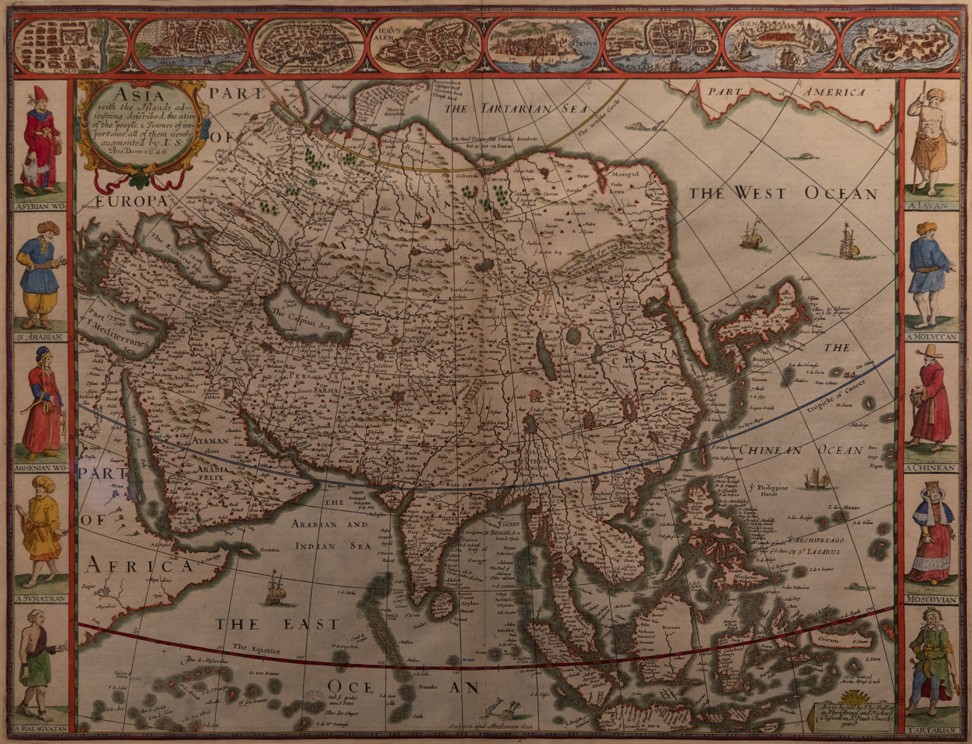
- [kuwaiti ministry of information] neibuhr visited the gulf and arabian peninsula between 1763-5. He talked about the prosperity achieved by kuwait and that its people owned more than 800 ships. He also mentioned that kuwait developed into a civilised community that worked in trade, pearl diving and ship building
- Sir Charles Lyell, 1st Baronet, FRS (14 November 1797 – 22 February 1875) was a Scottish geologist who popularised the revolutionary work of James Hutton. He is best known as the author of Principles of Geology, which presented uniformitarianism–the idea that the Earth was shaped by the same scientific processes still in operation today–to the broad general public. Principles of Geology also challenged theories popularised by Georges Cuvier, which were the most accepted and circulated ideas about geology in Europe at the time. His scientific contributions included an explanation of earthquakes, the theory of gradual "backed up-building" of volcanoes, and in stratigraphy the division of the Tertiary period into the Pliocene, Miocene, and Eocene. He also coined the currently-used names for geological eras, Palaeozoic, Mesozoic and Cenozoic. He incorrectly conjectured that icebergs may be the emphasis behind the transport of glacial erratics, and that silty loessdeposits might have settled out of flood waters.Lyell was born into a wealthy family, on 14 November 1797, at the family's estate house, Kinnordy House, near Kirriemuir in Forfarshire. He was the eldest of ten children. Lyell's father, also named Charles Lyell, was noted as a translator and scholar of Dante. Also an accomplished botanist, it was he who first exposed his son to the study of nature. Lyell's grandfather, also Charles Lyell, had made the family fortune supplying the Royal Navy at Montrose, enabling him to buy Kinnordy House.
- Alfred Russel Wallace OM FRS (8 January 1823 – 7 November 1913) was a British naturalist, explorer, geographer, anthropologist, and biologist.[1] He is best known for independently conceiving the theory of evolution through natural selection; his paper on the subject was jointly published with some of Charles Darwin's writings in 1858.[2] This prompted Darwin to publish his own ideas in On the Origin of Species. Wallace did extensive fieldwork, first in the Amazon River basin and then in the Malay Archipelago, where he identified the faunal divide now termed the Wallace Line, which separates the Indonesian archipelago into two distinct parts: a western portion in which the animals are largely of Asian origin, and an eastern portion where the fauna reflect Australasia. He was considered the 19th century's leading expert on the geographical distribution of animal species and is sometimes called the "father of biogeography".[3] Wallace was one of the leading evolutionary thinkers of the 19th century and made many other contributions to the development of evolutionary theory besides being co-discoverer of natural selection. These included the concept of warning colouration in animals, and the Wallace effect, a hypothesis on how natural selection could contribute to speciation by encouraging the development of barriers against hybridisation.
- Ferdinand Freiherr von Richthofen (5 May 1833 – 6 October 1905), better known in English as Baron von Richthofen, was a Germantraveller, geographer, and scientist. He is noted for coining the terms "Seidenstraße" and "Seidenstraßen" = "Silk Road(s)" or "Silk Route(s)" in 1877. He also standardized the practices of chorography and chorology. He was born in Carlsruhe, Prussian Silesia, and was educated in Breslau and Berlin. He traveled or studied in the Alps of Tyrol and the Carpathians in Transylvania. In 1860, he joined the Eulenburg Expedition, a Prussian expedition which visited Ceylon, Japan, Taiwan, Celebes, Java, the Philippines, Siam, Burma between 1860 and 1862. No important work resulted from these travels, for much of Richthofen's records and collections was lost. China was at the time inaccessible owing to the Taiping rebellion, but Richthofen was impressed with the desirability of exploring it.[3] From 1862 to 1868, he worked as a geologist in the United States, discovering goldfieldsin California. He then followed up his interest in China by several more trips there, and also to Japan, Burma, and Java. In China he located the dried-up lake bed of Lopnur. He published his geographical, geological, economic, and ethnological findings in three volumes with an atlas, which, however, did not cover the entire field or complete the author's plan. This work appeared at Berlin in 1877-85 under the title of China; Ergebnisse eigner Reisen und darauf gegründeter Studien. In this standard work, the author deals not only with geology but with every subject necessary to a general geographical treatise. Notably he paid close attention to the economic resources of the country he traversed. He also wrote a valuable series of letters to the Shanghai Chamber of Commerce, and first drew attention to the importance of the coalfields of Shantung, and of Kiaochow as a port. He was appointed professor of geology at the University of Bonn beginning in 1875, but being fully occupied with his work in China he did not take up professorial duties until 1879. He became professor of geography at the University of Leipzig in 1883, and professor of geography at the Friedrich Wilhelm University of Berlin in 1886. He occupied the latter position until his death. His lectures attracted numerous students who subsequently became eminent in geographical work, and in order to keep in touch with them he established his weekly geographical “colloquium.” Among his most famous students was Sven Hedin, the Swedish explorer. He served as president of the German Geographical Society for many years and founded the Berlin Hydrographical Institute.
- Sir Halford John Mackinder PC (15 February 1861 – 6 March 1947) was an English geographer, academic, politician, the first Principal of University Extension College, Reading (which became the University of Reading) and Director of the London School of Economics, who is regarded as one of the founding fathers of both geopolitics and geostrategy. Mackinder was born in Gainsborough, Lincolnshire, England, the son of a doctor, and educated at Queen Elizabeth's Grammar School, Gainsborough (now Queen Elizabeth's High School), Epsom College and Christ Church, Oxford. At Oxford he started studying natural sciences, specialising in zoology under Henry Nottidge Moseley, who had been the naturalist on the Challenger expedition. When he turned to the study of history, he remarked that he was returning "to an old interest and took up modern history with the idea of seeing how the theory of evolution would appear in human development". He was a strong proponent of treating both physical geography and human geography as a single discipline. Mackinder served as President of the Oxford Union in 1883.
- he envisioned global history as a competition between maritime and continental powers. He announced a change in power relations to the advantage of continental powers, with technological improvement of railways and relative erosion of advantage of nations with strong navies (such as the UK). Thanks to industrialisation and the promise of railway infrastructure, continental powers such as russia and germany were new challengers to the maritime power of britain. They were also searching for a maritime opening, creatijng and promoting their sparse harbor cities and developing their navies to compete with the british.
- Amadeus William Grabau (January 9, 1870—March 20, 1946), the father of Chinese geology, was an expatriate American geologist. Grabau was a German-American paleontologist and geologist, born in Cedarburg, Wisconsin in the United States who died in Peking, China. His grandfathers had led dissident Lutheran immigrants from Germany to Buffalo, New York. His education began in his father's parochial school in Cedarburg, and then the public high school there. After his father became head of the Martin Luther Seminary in 1885, he finished high school in Buffalo. He took classes in the evenings while apprenticed to a bookbinder. His interest in local fossils grew. In a correspondence course in mineralogy, he impressed geologist William Otis Crosby enough to hire him at the Boston Society of Natural History in 1890, and arrange his education at Boston Latin, MIT, and Harvard.
He taught at MIT and Rensselaer Polytechnic Institute early in his career. In 1901 he became a professor at Columbia University in New York. He married Barnard student Mary Antin on October 5, 1901. She would go on to become a prominent author. The pro-German attitudes during World War I led to an estrangement from his wife, and in 1919 he left Columbia for China. He was appointed professor at Peking National University in 1919 or 1920. As part of his life's work, he conducted a geologic survey of China, and is now known as the father of Chinese geology. During World War II he remained in Peking. Around 1941 he was interned by the Japanese Imperial Army. His health declined precipitously, and he died of an internal hemorrhage after his release.
map
- bedolina map (carved in stone) around 1000 bc, in val camonica, italy
- around 2500 years ago, the camuni came into contact with etruscans (who lived further south) from whom they learned how to write alphabet letters. Map to show symbolic power the aristocracy held over the landscape
- raevehoj (on island of fyn in denmark, houses a hidden burial chamber from stoneage)
- wall painting in catalhoyuk, turkey, featuring mount hasan
- round cave painting in atlas mountain in talat n'lisk, morocco
- rock carving at cangyuan region of southwest china (reminiscent of bedolina map)
- stone at lydenburg in south africa
- rock carvings along yenishi river, mugur-sargol in mongolia
- map found close to kirkuk in northern iraq crated around 2300bc, first to indicate directions east, west and north, with east at the top
- on a vase
- silver vase in n caucasus mountains showing two rivers
- vase from tepe gawra near mosul in iraq
- [tr berg] greeks called europe, asia and africa (separated from asia by the nile) oikoumene. The word stems from oikeo, to dwell, and means the inhabited world. oikoumene stretched from gibraltar in the west to india in the east, and from ethiopia in the south tothe mystical hyp9erborea (means beyond the north) in the north. Boreas was greek god of north wind, depicted as a bearded and dishevelled man with ice in his hair, father of chione, goddess of snow. He ruled over the riphaean mountain rangevto the far north. Callisto had a sonnwith the god zeus. Zeus's furious wife then turned callisto into a bear as punishment. When callisto's son grew up, he came close to killing his mother the bear while out hunting, but zeus prevented the tragedy by lifting them up into the sky as the constellations ursa major and ursa minor - the great bear and the little bear. The greeks believed that the riphaean mountains were located directly below bootes, the great bearand the little bear, because these constellations are always seen in the skies to the north. The northern regions were named the arctic because arktos is the greek word for bear. The pole star is the brightest star in little bear. Maps could be graved on bronze tablets. Crates of mallas created a globe - directly south of equator is antoikoi (those who live on the other side), on the other side of northern hemisphere perioioi (those who kive nearby)and south of this the antipodes (those with their feet the other way). Greek mathematician pythagoras had the idea that people lived on the other side of the globe.
- [tr berg]
- tabula peutingeriana - probably created during 335, 336, include britain, spain, morocco, sri lanka and china
- de situ orbis (description of the world)
- anglosaxon translation of orosius's historiarum (which only described the world south of the alps) added description of journey by norwegian seafaree ohthere of halogaland
- naturalis historia by pliny the elder - include iberian peninsula, britain, serere (china), scandinavia, ethiopia
- europeans of early 1400s finally had access to ptolemy's geography in latin translation
- include where the finnas have their camps, white sea in russia, norway was described as a long, narrow country, svealand, alongside the northern part the land of the kvens. Ohthere was a merchant, and often travelled south to skiringssal, a market town not far from where larvik is situated today. From there, he travelled on to hedeby in denmark. The angkes lived in these districts before they came to this land. Islands on the port side belong to denmark. Oldest description of noroweg (norway)
- [tr berg] image of jesus holding globe in the way as roman god jupiter, to show that he rules over the world. 12 winds that encircle world have classical names. North of norwegia is island of hyperboreans, a people who according to greeks lived where the north wind started, and even further north the island of aramphe, also a feature of far north in greek myths. At the very top, furthest east, is garden of eden. A round mas with jerusalem at the centre and strange beings living on its outskirts - including peoplevwith dog heafs not far from noreya.
- catalan atlas 1375 probably created by cresques abraham in mallorca - include europe and north africa
- [tr berg] presented to king of france from king of aragon, providing an overview of the known and not so well known world from canary islands in the west to sumatra and china innthe east. regio de nuruega is situated beside suessia and dasia, completely surrounded by mountains. This region of norway is very rugged , very cold, mountainous, wikd and covered with forests. There are also many beasts, like deer, white bears and gyrfalcons.
- fra mauro's world map 1460
- [tr berg] mauro was from monastery of st michael, one of the islands in venice;marks end of medieval, biblical map tradition - did not place paradise in far east, he had read about the travels of marco polo
- renaissance map printed by nicolaus germanus in ulm in 1482
- no china but note places beginning with sinul, sina
- asia seemed to be easily reached by ship from europe, because behaim underestimated the size of earth and placed japan around where mexico is located. From the island of antilia, supposed to be situated out in the sea to the far west and populated by portuguese who had fled there several hundred years earlier, it is only 50 degrees of longitude to the coast of japan
- include an over-dimensioned taprobane (sri lanka), island of isabella (cuba); america presented as a separate continent, first time 'america' is used. Waldseemuller named northern part of america as terra de cuba. asie partis (land of cuba, part of asia) in a nautical chart in 1516
- no china but chatay, there is java major and java minor
- giacomo gastaldi's edition of geography in 1548
- [tr berg] first edition to be published in italian and to feature engraved maps of the american continent
- cover of book presents four and a half continentsvrepresented bybfemale figures. At the top, europe sits on a throne, wearing a crown, two globes placed to her left and right. Directly beside her is a third globe, which she's holding with the help of a cross, as she's responsible for bringing christianity to the world. Asia is also clad in noble robes, but has a tiara rather than a crown, and is subordinate to the european queen, as is africa - more sparsely clad and wearing a halo inspired by the sun to emphasise the heat where she lives. At the very bottom is their american sister, but little about her is reminiscent of advanced civilisations - the incas, mayans and aztecs - encountered by spanish. This is primitive, cannibalistic america, holding a european man's head in her hand - naked and armed, she is a femme fatale who both seduces and devours european men. Beside her is a bust that represents the yet only partly discovered continent furthest south: terra australis nondum cognita - the southern land not yet known. A separate map of north pole is included, it is symmetrically surrounded by four large islands (prepared based on account of an english monk who visited the region in 1360 and his book inventio fortunata (the discovery of fortunata). book was given to king of england as a gift butbhas since been lost. mercator learned of the book from itinerarium by jacobus cnoyen, in which the monk's tale is retold by a priest from the northern regions who visited king magnus in bergen in 1364. According to the book, the pole itself was a huge, black mountain of magnetic stone. The island closest to europe (believed to be nowadays baffin bay), which bordered on norway, was inhabited by people no more than four feet tall.). The depiction of greenland is strikingly correct. iceland had been fairly inaccurately represented on his map of europe from 1554.
- Antoine-Augustin Bruzen de La Martinière or de la Martiniere (1662 at Dieppe – 19 June 1746 in The Hague), was a French polymath. His main work was the Grand Dictionnaire Geographique Et Critique published in ten volumes between 1726 and 1739. Thanks to the munificence of his patrons, he lived at the court of Friedrich Wilhelm, Duke of Mecklenburg-Schwerin, then Francesco Farnese, Duke of Parma. He was also employed by king Philip V of Spain.La Martinière was born in Dieppe in 1662 and grew up in Paris with his uncle, the theologian and historian Richard Simon. In 1709 he went to the court of Duke Friedrich Wilhelm of Mecklenburg. After Friedrich Wilhelm's death in 1713, La Martinière entered the service of Francesco Farnese, the Duke of Parma, who sent him on a diplomatic mission to the Netherlands. In Amsterdam he undertook many translations and compilations. As Secretary of the Philip V, King of Sicily and Spain, La Martinière received a pension of 1,200 ECU. After several years in the Netherlands, La Martinière moved to the Hague, where he lived until his death in June 1746.La Martinière's main work is the 10 volume Grand Dictionnaire Geographique Et Critique, of which the first volume appeared in 1726 in the Hague. It is one of the most extensive geographical works of the 18th Century. On the advice of the Marquis Beretti Landi, Ambassador of Spain to the States-General of the Netherlands, La Martinière dedicated the work to the Spanish King Philip V. In Germany, the work was translated and expanded under the title Historical and Political-Geographic Atlas of the whole world. The alphabetical volumes of the German edition were published in 1744-1749, and a supplementary volume in 1750. The publisher was Johann Samuel Heinsius of Leipzig, but the translation and expansion project was initiated by his partner Johann Heinrich Zedler. The Grand Dictionnaire Geographique Et Critique was published in several editions after La Martinière's death, such as a six-volume revised edition in Paris in 1768.
- [tr berg]cram's atlas of the world from 1901- world according to hecataeus (around 530bc, world in two parts - upper europa and lower asia which include libya and arabia, he was aware of both indus river and caspian sea); herodotus (around 450bc, include europa, libya, asia (including parts beyond caspian sea); strabo (around 25bc, include europa, scythia, libya, arabia felix, asia which includes ariana and india) and eratosthenes (around 225bc, include europe, libya, arabia, asia which includes scythia, ariana, india; note land of the kinnamomom (cinnamon) bearers, which the greeks thought lay somewhere south of khartoum)
- [tr berg] indonesia is sundaoerne; bangladesh, india, pakistan are for-indien; namibia is tysk sva; botswana, lesotho, swaziland, s africa, zambia and zimbabwe are rhodesia; germany and baltic is tyskl; ottoman empire is tyrk; tanzania is tysk oa; russia is rusland; great britain is de brit oer; usa is de forenede stater
- students of academic year 1902/3 became the first in norway to peruse an atlas by ivar resfdal. Continually reprinted, it became a permanent fixture of classrooms until well into 1960s.
- height of norwegian arctic ocean imperialism, western arctic is titled nordamerikas arktiske oer (north america's arctic islands), and states that the lands discovered by sverdrup are coloured red
- nautical charts
- carta pisana 1275
- [tr berg] from genoa not pisa
- map in 1339 shows an african king, the queen of saba in arabia, a large area of africa to the south and asia in the east
- de kaert vader zee (nautical chart) by jan seuerszoon in 1532
- olausvmagnus's carta marina from 1539
- spieghel der zeevaerdt (mariner's mirror) by lucas janszoon waghenaer in 1584
- het licht der zeevaert (the light of navigation) by william blaeu in 1608
- [tr berg] by vikings, the hauksbok (bookof haukr) from 1308 provides an example
- aerial mapping
- ww1 paved the way
- general map of seas explored by north sea expedition in 1878
- floor of atlantic ocean signed by geologists marie tharp and bruce heezen in 1956
- world ocean floor panorama by marie tharp, bruce heezen and heinrich berann, completed in 1977 - 1st map to show how all the subsea mountain ranges link together
- global marine gravity 2oct2014 by geophysicists davidvsandwell and walter smith using satellite images that show where gravitation is strongest
- global positioning system completed in 1994, with a total of 24 satellites in orbit around the earth
- world map
- 現時在教科書上常見的平面世界地圖,是德國地圖學家麥卡托於一五九六年繪製,但不同大陸的面積比例其實被嚴重扭曲。英國氣象局近日以可視覺化統計軟件,重新繪畫一幅立體世界地圖,將真實比例呈現出來。http://orientaldaily.on.cc/cnt/china_world/20181115/00180_037.html
- 英國紐卡素大 學(Newcastle University)社會地理學 教 授 阿 拉 史 泰 爾 . 邦 尼 特 (Alastair Bonnett) 所 著 作 的 《 圖 外 之 地 》 ( Beyond the Map)。這本書介紹了三十 九個頗有特色的地方,例如 「上升的島 嶼」、 「邦代海灘的線牆」、 「撒哈拉沙牆」等,探究其地 理屬性和人文屬性。 我對這本書的第一個感覺是世界之大,遠在地圖外。雖 然我也算是個地理愛好者,但本書中談及的許多地方我都聞 所未聞,即使通過Google Map,書中提到的部分地方資訊仍 相當有限。例如,有因為海平面上升而徹底消失的、被作者 譽為英國與荷蘭之間的海中龐貝城—多格蘭(Doggerland) ,還有因為地質運動在波斯尼亞灣新生成的島嶼(Bothnia's Rising Islands)。還有基於宗教原因而形成的概念上的邊界 —邦代海灘的線牆(The Eruv at Bondi Beach)。無論新生 成的陸地還是已有的陸地,大多因為帶有經濟利益而受到各 方爭奪。 例如有關 「美國本土外小島嶼」的一篇提到,美國 一八五六年《鳥糞島嶼法》(Guano Island Acts)鼓勵美國公 民在無人、無政府管轄的島嶼宣稱美國主權,目的是為了爭 取從海岸線延伸出的經濟領域。但一旦陸地環境因各種原因 受到破壞(大多數是環境破壞),它們即被拋棄或荒廢。http://paper.takungpao.com/resfile/PDF/20190216/PDF/b4_screen.pdf
- making of maps
- companies/people
- making of maps
- Portolans were maps indicating the positions of ports with fairly reasonable accuracy and provided multiple rhumb lines (that’s those networks of compass rose thingies) for captains to use to set headings when heading from one port to the next. Inland navigation, where you might have to go up and down and around various land features, was still trickier than navigation at sea, where you could pretty much always go in a straight line. One consequence of that is that—and you can see this if you squint at that map really hard—portolans really just marked points of navigation. Most of the contents of that map are the locations of ports without the coastline being drawn in most spots. The land forms are barely outlined if at all and show very few internal features. Full maps only followed after that in the Renaissance and beyond.https://www.quora.com/How-did-mapmakers-in-the-middle-ages-get-the-general-shape-and-size-of-landmasses-right-Especially-in-Europe-considering-they-lacked-a-bird-s-view-of-it-all
- companies/people
- blaeu brothers
- willem blaeu was appointed east india company's official cartographer in 1632
- hondius
- [tr berg] jodocus hondius the younger was the second generation in cartographic dynasty founded by his father. The hondiusvfamily dominated the dutch mkt for atlases - foundations laid back in 1604 when hondius the elder paid a significant sum for mercator's copper plates at auction.
- janssonius
- Reiner Ottens and his brother Joshua have been active in map printing and selling during the first half of 18th Century. The family business was founded by their father Joachim, but most productive during the time of Reiner and Joshua.https://www.vintage-maps.com/en/ottens-reiner-144
- [kuwaiti ministry of information] published a map of 1737 showing the borders between kuwait and the ottoman state, kazima name is apparent indicating kuwait's location
- jonston
- eg. 1874 grand atlas of arabian peninsula and parts of asia
- Stanfords is a specialist bookshop of maps and travel books in London, established in 1853 by Edward Stanford. Its collection of maps, globes, and maritime charts is considered the world's largest. It has also supplied cartography for the British Army and for James Bond films.At the time of the shop's opening, it was the only mapmaker in London since it commissioned John Bolton as an in-house cartographer. Stanfords opened at the height of global exploration and colonialism, hence, cartographic works were in great demand. The shop quickly expanded to 7 and 8 Charing Cross whilst acquiring premises on Trinity Place for printing works. The store on Long Acre in Covent Garden, central London, was the location of the company's printing business[3] before the entire operation moved there in January 1901.In 1877, Stanfords acquired the prestigious Staunton & Son, which was recognized as the official “Stationers to the Queen”.Stanfords was hit by an incendiary bomb in 1941 and it only survived due to the thousands of Ordnance Survey maps tightly stacked on the shop's upper floors, which kept the fire from spreading.For the shop's 150 year anniversary, a National Geographic world map was imposed onto the Ground Floor, as well as a map of the Himalaya and London on the other floors, costing £40,000. In 1997 a second store opened in Bristol. The company also operates a division based in Manchester providing mapping for business purposes such as large scale maps for planning applications.In 2018 Stanfords opened a new location at 7 Mercer Walk in Covent Garden and in 2019 closed the historic Long Acre site and relocated to Mercer Walk.
- wideroe company
- aerial maps
- silicon graphics
- private collection, historical maps
- The David Rumsey Historical Map Collection is one of the world's largest private map collections. It has over 150,000 maps and cartographic items. The collection was created by David Rumsey who, after making his fortune in real estate, focused initially on collecting 18th- and 19th century maps of North and South America, as this era "saw the rise of modern cartography."More recently, Rumsey has expanded the collection to include maps from the 16th though 21st centuries, and covering the entire world. There are now over 97,000 digitized maps available through his website, http://www.davidrumsey.com, about 1000 of which are currently being hosted through Google Earth layers.
- https://press.uchicago.edu/books/hoc/index.html
geography book
- The Ḥudūd al-ʿĀlam (Arabic: حدود العالم "Boundaries of the World" or "Limits of the World") is a 10th-century geography book written in Persian by an unknown author from Jowzjan. The title in full is حدود العالم من المشرق الی المغرب (Ḥudūd al-ʿĀlam min al-Mashriq ilá l-Maghrib, "The Boundaries of The World from The East to the West").
In English, the title is also translated as "The Regions of the World" following Vladimir Minorsky's 1937 translation, in which he commented on the title as follows: "The word ḥudūd (properly 'boundaries') in our case evidently refers to the 'regions within definite boundaries' into which the world is divided in the Ḥ.-'Ā., the author indicating with special care the frontiers of each one of these areas, v.i., p. 30. [As I use the word "region" mostly for nāḥiyat it would have been better, perhaps, to translate Ḥudūd al-Ālam as "The limited areas of the World".]"Finished in 982 CE, it was dedicated to Abu'l Haret Muhammad, the ruler of the Farighunids. Its author is unknown, but Vladimir Minorsky has surmised that it might have been written by the enigmatic Šaʿyā bin Farīghūn, author of a pioneer encyclopedia of the sciences, the Jawāmeʿ al-ʿUlum, for an amir of Čaghāniān on the upper Amu Darya in the mid-10th century.The Orientalist Russian scholar Alexander Tumansky found a manuscript with a copy of this text in 1892 in Bukhara.
travel book
- 海國勝遊草天外歸帆草https://ctext.org/wiki.pl?if=gb&res=687050
land surveying
- ancient egyptians and sumerians used triangulation many years earlier when measuring their lands and drawing maps.
- in 1600, leiden university started offering a programme of study within mathematics, engineering and land surveying, and textbooks such as practijck des lantmetens (land surveyor practice) were published the same year. The dutch engineers soon gained a reputation for their innovative practices.
- france was the first country to use modern triangulation methods on a large scale. Method was refined by italian astronomer giovanni cassini
- triangulation of great britain started as a result of french invitation in 1783
trivial
- https://www.quora.com/Does-the-fact-that-the-Romans-called-the-world-orbis-mean-they-were-aware-that-the-Earth-is-a-sphere
No comments:
Post a Comment